Mapping and Surveying Services
Millennium UAV utilizes professional, commercial grade UAV’s and cameras to capture highly precise and accurate aerial data. We improve efficiencies as we are able to perform these tasks in less time and at reduced costs compared to traditional methods. When processed, the output delivered will contain extremely accurate, georeferenced data that will provide our business partners the actionable data they need to enhance their decision processes.
What is surveying and mapping?
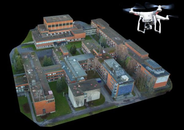
Surveying is the science of determining the precise positioning of, and distances between points in 2D and 3D space. Mapping is the term used to describe the rendering of aerial photos into precise georeferenced 2D maps and 3D models via a process called Photogrammetry.
What are the benefits?
The greatest advantage of Implementing UAV’s for surveying and mapping is Time. Traditionally, these would be conducted on the ground and require meticulous measurement, preparation, and planning. Today, Drones can conduct aerial surveys capturing comparable data in dramatically shorter time frames. The deliverable’s produced in the form of ( 2D maps and 3D modlels ) contain highly precise and actionable data.
Millennium Surveying & Mapping Benefits
Quicker Results
Aerial surveys can be conducted in much less time than ground-based surveying. Faster data gathering leads to quicker results.
Reduced Cost
Drones proved cost savings in several areas. They gather data more rapidly reducing field time. They produce quality results quickly, profitably, and safely
Risk Mitigation
Drones make it no longer necessary for human operators to physically access and measure points in hazardous or difficult-to-reach locations.
Precision Land Management
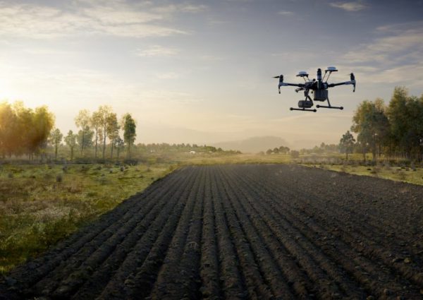
Managing resources is vital to any business. Resources can vary but maximizing whats available is always the desired goal. When it comes to managing land resources, determining the best approach has often been met with many challenges such as sheer size, hazardous conditions and environmental obstacles. Thankfully, today, we have the tools and technology that allow us to better manage our resources for maximum efficiency. Implementing UAVs with advanced UAV technology, we can overcome past obstacles and deliver data quicker and with a higher degree of accuracy.
Site survey’s can be conducted using UAVs with RTK technology to provide greater accuracy than satellites. Combine the use of GCP and you can deliver almost absolute accuracy. Farmers could use this to generate a more accurate terrain map for their autonomous equipment. Surveying with a Spectral camera can show overall plant health and help isolate problem areas. Utilizing the precisely obtained geo data can allow more targeted approaches to managing chemical disbursements for Agriculture, Golf courses and other Land Development entities.
Precision Land management encompasses just about every industry. If you grow, build, or develop, there is a UAV technology that can assist you in maximizing your resources. Determining a need for UAS technology is the first step. Partnering with the right team is just as crucial for optimal results. Millennium UAV will be that partner you can count on to deliver your objectives.
Volume Measurements
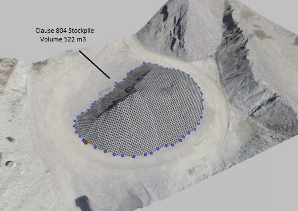
Managing stockpile inventory has been one of the biggest challenges facing industries that need regular volume data reports. While there are a number of viable methods to capture these measurements, drones have become a preferred method to measure stockpile volumes. Drones provide enhanced accuracy, safety, timeliness and reduced costs.
Drones are capable of producing high resolution images that contain Geo taged data. This data when collected with fine GSD’s and combined with GSP’s are extremely accurate Geo referenced points. Out of these photos, photogrammetry software is used to stich the images into a point cloud which contains thousands of data points. The software can use this data to recreate geo-referenced 3D maps, contour lines digital terrain models or digital surface models. As the point cloud contains thousands of data points, very accurate volume calculations can now be performed.
Thermal
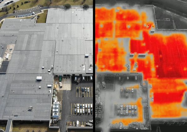
Thermal images can provide much more valuable data than what can be obtained from standard RGB images. Using cameras with different sensors, we can capture IR (Infrared) images not visible in the normal light spectrum. These cameras are able to convert the radiation (Heat) into visible light pictures. From these images we can identify objects in total darkness, dense smoke and accurately measure temperature differences. These cameras have the ability to capture the images in a variety of color pallets. Depending on your particular applications, these differnt color pallets can make it easier to distinguish your subject matter for more accurate diagnosis.
This technology can offer tremendous benefits to a variey of Industry.
- Utility Inspections.
- Commercial Building Inspections.
- Residential Roof Inspections.
- Industrial Inspections.
- Wildlife Management.
- Fire Fighting.
- Search and Rescue.
Orthomosaic
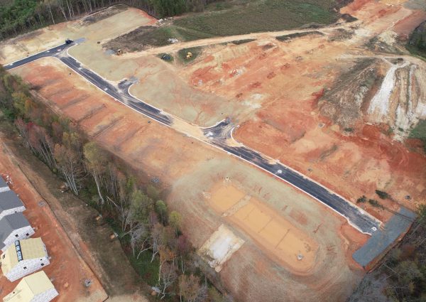
Orthomosiac maps are probably the most commonly produced maps when it comes to UAV mapping. These maps are high resolution 2D replicas of an area, encompassing hundreds or thousands of photos, that when stitched together during post processing, contain geometrically corrected “orthorectified” images so that it is as accurate as a map. Adding Ground Control Points can provide improved geo-referenced data points.
Other output formats such as a DSM ( Digital Surface Model ), DTM ( Digital Terrain Model ) and 3D models can be compiled from the point cloud generated data. Othos are accurate to scale, provide great visual representation of an area and allow interaction with the ability to zoom in to specific areas as well as tilt and rotate to get full 360 degree coverage.
Deploying UAV’s for mapping and utilizing the data produced through Photogrammetery can provide your business or organization with distinct opportunites. Millennium UAV can provide you with the deliverables needed to aid you throughout your project lifecycle.
3D Modeling
3D models are another great deliverable provided by utilizing UAV’s and Photogrammetry software. The output generated from the stitched images provide a great way to visualize the 3 dimensionalities of your object of interest. The ease, simplicity, and geometric accuracy of 3D models produced by drone images make them a valuable asset across numerous applications for a variety of industries.
These georeferenced models provide very accurate and detailed data allowing customers to easily extract information such as volume, slope, structural and various other details. The model file can easily be imported into other software such as AutoCAD and other GIS software.
NDVI
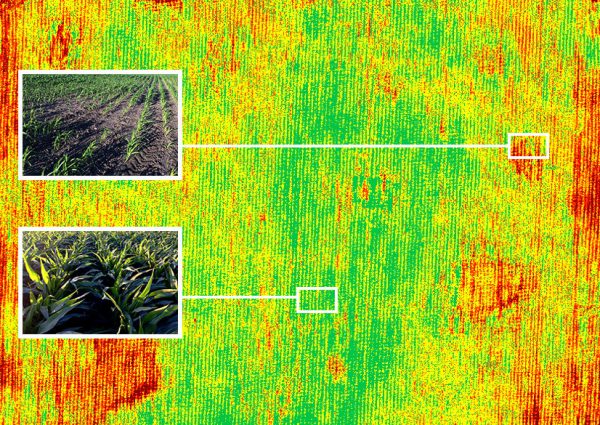
NDVI or ( Normalized Difference Vegetation Index ) quantifies vegetation by measuring the difference between near-infrared (which vegetation strongly reflects) and red light (which vegetation absorbs). NDVI is a simple metric which indicates the health of vegetation. Healthy vegetation (chlorophyll) reflects more near-infrared (NIR) and green light compared to other wavelengths. But it absorbs more red and blue light. This is why we see vegetation as green.
NDVI has been used for the past 40 years as the go-to method of assessing plant health. Satellites and Airplanes have been the traditional methods used to capture images. These methods were expensive and could take considerable time to deliver. Today, drones are completely changing the game. They can provide images in real time at a fraction of the cost. Utilizing NIR cameras or RGB cameras with the VARI algorithm, Drones can make field scouting faster and more effective.
Plants react to stresses in near-infrared bands much earlier and more drastically than in the visible bands of light we see. Bottom line is Land management personnel want to see this stress as soon as possible so they can get out to the field and figure out a solution.
FINDING THE RIGHT DRONE SOLUTION !
Today, businesses are tasked with doing more for less. Drones are able to meet that demand and deliver solutions to just about every industry challenge. Millennium UAV will partner with you to customize specific packages that meet your particular business requirements.
Ready To Get Started ?
